


| Re: Warnings of snow, wind and rain across the UK for January 2025 Posted by Chris from Nailsea at 19:41, 28th January 2025 |     |
A further update, from the BBC:
Why stormy UK weather is likely to continue for the rest of winter
Storm Éowyn was one of the most exceptional storms of the decade according to the Met Office with 100mph (160km/h) winds recorded in Scotland.
The fifth named storm of the season brought widespread disruption and damage, and sadly two deaths.
Strong winds and heavy rain continued into the start of the week as Storm Herminia rolled through.
But as we head into February and the last month of winter, what is the long-range forecast? Well we are probably going to have to be ready for further stormy weather at times.
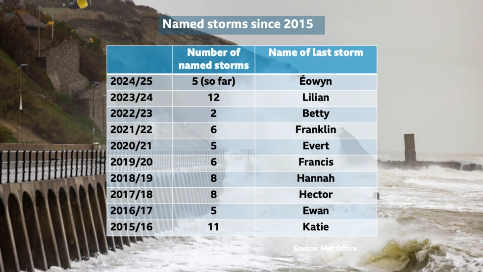
Since the Met Office started naming storms in 2015 the most active season was in 2023/24 with 12, when we reached the letter L - for Lilian - in the alphabet of named storms. The year before that, there were only two.
With so much natural variability in our weather, the number of named storms we experience each year is influenced by other meteorological patterns around the world and so it is difficult to directly compare storminess to previous years.
Winter is defined in meteorology as December, January and February.
Up until now we have had a real mix of unsettled weather with five named storms but we also had a significant cold snap in early January. With -18.9C recorded in Altnaharra, Highland on 11 January it was the coldest January night in the UK for 15 years. Widespread snow and ice caused disruption across the UK.
However, long-range weather forecasts are hinting at the opposite for the rest of winter. An active jet stream - the fast moving air high in the atmosphere - appears to be the dominant driver for weather conditions and this is likely to bring frequent low pressure systems across north-west Europe.
In its three-month forecast, the Met Office suggests that the chances of impacts from wet and windy weather is increased compared to normal, particularly throughout February. It also says "the increased risk of storms gives rise to a greater risk of 'storm clustering', with consecutive events affecting the UK in quick succession".
DTN, the forecast provider for BBC Weather, also suggests that "risks of disruptive wind events are likely to be higher, especially during February".
(Article continues)
Storm Éowyn was one of the most exceptional storms of the decade according to the Met Office with 100mph (160km/h) winds recorded in Scotland.
The fifth named storm of the season brought widespread disruption and damage, and sadly two deaths.
Strong winds and heavy rain continued into the start of the week as Storm Herminia rolled through.
But as we head into February and the last month of winter, what is the long-range forecast? Well we are probably going to have to be ready for further stormy weather at times.
Since the Met Office started naming storms in 2015 the most active season was in 2023/24 with 12, when we reached the letter L - for Lilian - in the alphabet of named storms. The year before that, there were only two.
With so much natural variability in our weather, the number of named storms we experience each year is influenced by other meteorological patterns around the world and so it is difficult to directly compare storminess to previous years.
Winter is defined in meteorology as December, January and February.
Up until now we have had a real mix of unsettled weather with five named storms but we also had a significant cold snap in early January. With -18.9C recorded in Altnaharra, Highland on 11 January it was the coldest January night in the UK for 15 years. Widespread snow and ice caused disruption across the UK.
However, long-range weather forecasts are hinting at the opposite for the rest of winter. An active jet stream - the fast moving air high in the atmosphere - appears to be the dominant driver for weather conditions and this is likely to bring frequent low pressure systems across north-west Europe.
In its three-month forecast, the Met Office suggests that the chances of impacts from wet and windy weather is increased compared to normal, particularly throughout February. It also says "the increased risk of storms gives rise to a greater risk of 'storm clustering', with consecutive events affecting the UK in quick succession".
DTN, the forecast provider for BBC Weather, also suggests that "risks of disruptive wind events are likely to be higher, especially during February".
(Article continues)
| Warnings of snow, wind and rain across the UK for January 2025 Posted by Chris from Nailsea at 20:52, 27th January 2025 | |
Would it not be sensible to aggregate these storm notices into one thread?
A good suggestion, ChrisB: I have now done that. CfN.

| Re: Storm Éowyn set to batter the UK with up to 90mph winds - Friday 24 Jan 2025 Posted by broadgage at 04:11, 27th January 2025 | |
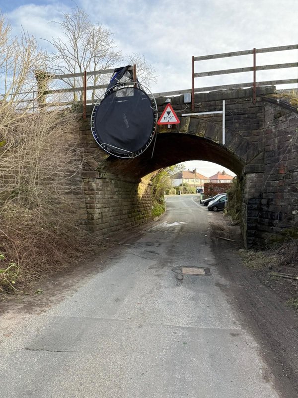
Image from Network Rail posted on Facebook, along with a request for those living near railway lines.
It could be worse, there appears to be no obstruction to trains on the bridge, and almost no obstruction to road vehicle passing under the bridge. Only road vehicles bear the upper limit of height and width would be affected.
It's usually lorries we worry about hitting rail bridges.
It could be worse, there appears to be no obstruction to trains on the bridge, and almost no obstruction to road vehicle passing under the bridge. Only road vehicles bear the upper limit of height and width would be affected.
| Re: UK hit with high winds as Storm Herminia rolls in - Jan 2025 Posted by ChrisB at 19:24, 26th January 2025 | |
Would it not be sensible to aggregate these storm notices into one thread?
| UK hit with high winds as Storm Herminia rolls in - Jan 2025 Posted by Chris from Nailsea at 17:48, 26th January 2025 | |
From the BBC:
High winds have brought power cuts across the southwest of England as a new storm hit the UK on Sunday.
Berry Head, in Devon, recorded gusts of 83mph (133km/h) from the new storm, named Herminia, while power cuts were reported by thousands in Devon.
A 19-year-old man died when he was hit by a tree while driving in East Ayrshire on Friday during Storm Éowyn. He is the second death in the storm, with a 20-year-old man killed in County Donegal Ireland on Friday.
The Met Office has issued multiple yellow weather warnings for wind and heavy rain on Sunday and Monday, saying injuries and "danger to life" were a possibility.
Storm Herminia was named by the Spanish weather service Agencia Estatal de Meteorología (AEMET) on Friday and has now closed in on the UK, BBC Weather said.
More than 4,500 properties are now without power in Devon and Cornwall. National Grid said 2,968 properties have been hit in Cornwall, with another 1,488 in Devon.
National Rail said flooding between Par and Newquay has blocked the line and trains running between the two stations have been cancelled.
A Ryanair flight that was expected to land at Cornwall Airport Newquay at 07:35 GMT was diverted to London Gatwick.
People have been urged to stay away from the coast due to crashing waves. Maggie Howell, from Falmouth Coastguard, said the conditions out at sea were "really, really bad" on Sunday morning.
Forecasters said the storm brings a large risk of disruptive weather, especially across the southern half of the UK, which largely escaped Éowyn. "Southwestern areas certainly bearing the brunt this time in terms of the most unsettled conditions," Met Office meteorologist Jonathan Vautrey said.
Heavy rain is expected to move in across England, Wales, Northern Ireland and southern Scotland on Sunday, with between 10 and 20mm (nearly an inch) of rain expected to fall. Another band of rain will sweep in across England and Wales overnight into Monday, increasing the risk of flooding as the ground is already saturated.
"Given recent heavy rain, this extra rainfall could lead to some local surface water and river flooding," Mr Vautrey said.
Meanwhile, around 101,000 customers were still without power on Sunday following the devastation caused to the electricity network by Éowyn.
A yellow weather warning for wind and a yellow warning for snow and ice will be in place across Northern Ireland on Sunday. It comes two days after Éowyn brought winds of more than 90mph to Northern Ireland.
"Given ongoing recovery work after Storm Éowyn, impacts may be more widespread than would ordinarily be expected with winds of this strength," the Met Office said.
At the storm's height, nearly a million properties were without power across the British Isles, while many road and rail links were blocked.
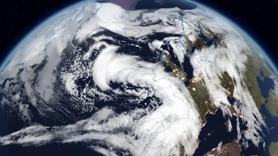
This satellite image shows the area of cloud that will bring strong winds and heavy rain to parts of the UK through Sunday and Monday
Berry Head, in Devon, recorded gusts of 83mph (133km/h) from the new storm, named Herminia, while power cuts were reported by thousands in Devon.
A 19-year-old man died when he was hit by a tree while driving in East Ayrshire on Friday during Storm Éowyn. He is the second death in the storm, with a 20-year-old man killed in County Donegal Ireland on Friday.
The Met Office has issued multiple yellow weather warnings for wind and heavy rain on Sunday and Monday, saying injuries and "danger to life" were a possibility.
Storm Herminia was named by the Spanish weather service Agencia Estatal de Meteorología (AEMET) on Friday and has now closed in on the UK, BBC Weather said.
More than 4,500 properties are now without power in Devon and Cornwall. National Grid said 2,968 properties have been hit in Cornwall, with another 1,488 in Devon.
National Rail said flooding between Par and Newquay has blocked the line and trains running between the two stations have been cancelled.
A Ryanair flight that was expected to land at Cornwall Airport Newquay at 07:35 GMT was diverted to London Gatwick.
People have been urged to stay away from the coast due to crashing waves. Maggie Howell, from Falmouth Coastguard, said the conditions out at sea were "really, really bad" on Sunday morning.
Forecasters said the storm brings a large risk of disruptive weather, especially across the southern half of the UK, which largely escaped Éowyn. "Southwestern areas certainly bearing the brunt this time in terms of the most unsettled conditions," Met Office meteorologist Jonathan Vautrey said.
Heavy rain is expected to move in across England, Wales, Northern Ireland and southern Scotland on Sunday, with between 10 and 20mm (nearly an inch) of rain expected to fall. Another band of rain will sweep in across England and Wales overnight into Monday, increasing the risk of flooding as the ground is already saturated.
"Given recent heavy rain, this extra rainfall could lead to some local surface water and river flooding," Mr Vautrey said.
Meanwhile, around 101,000 customers were still without power on Sunday following the devastation caused to the electricity network by Éowyn.
A yellow weather warning for wind and a yellow warning for snow and ice will be in place across Northern Ireland on Sunday. It comes two days after Éowyn brought winds of more than 90mph to Northern Ireland.
"Given ongoing recovery work after Storm Éowyn, impacts may be more widespread than would ordinarily be expected with winds of this strength," the Met Office said.
At the storm's height, nearly a million properties were without power across the British Isles, while many road and rail links were blocked.
This satellite image shows the area of cloud that will bring strong winds and heavy rain to parts of the UK through Sunday and Monday
| Re: Storm Éowyn set to batter the UK with up to 90mph winds - Friday 24 Jan 2025 Posted by Chris from Nailsea at 16:52, 25th January 2025 | |
To be honest, I have very limited sympathy with Ms Albutt and her contact at her destination.
Were they really completely oblivious to the weather warnings, issued up to a week before, about Storm Éowyn?
Latest update from the BBC: Éowyn strongest storm in 10 years, says Met Office

| Re: Storm Éowyn set to batter the UK with up to 90mph winds - Friday 24 Jan 2025 Posted by JayMac at 16:35, 25th January 2025 | |
Image from Network Rail posted on Facebook, along with a request for those living near railway lines.
It's usually lorries we worry about hitting rail bridges.
| Re: Storm Éowyn set to batter the UK with up to 90mph winds - Friday 24 Jan 2025 Posted by ChrisB at 21:25, 24th January 2025 | |
From the Worcester News
Great Western Rail train hits tree during Storm Eowyn
PASSENGERS heard a "massive bang" when a train travelling between Worcester and Hereford hit a tree.
The train, which left Worcester Foregate Street at 6.34pm was delayed by half an hour, with others now also disrupted.
Charlotte Albutt, who was travelling on the train, said she heard a "massive bang" as the train hit the tree, followed by a "shudder", only two minutes into the journey.
The train came to a halt, making a "screech noise".
Initially, crews onboard told passengers that they had stopped at a red light, but then confirmed to passengers that the train had hit a tree, checks would need to be carried out, and the journey would be delayed.
Ms Albutt said she felt "frustrated" at the delay, with the train also being cold.
She added that the delay had affected her plans, with someone waiting for her at her arrival station.
On the National Rail website, the company is currently showing trains as delayed, with one delayed due to a fault on the train in front.
| Re: Storm Éowyn set to batter the UK with up to 90mph winds - Friday 24 Jan 2025 Posted by Chris from Nailsea at 21:01, 24th January 2025 | |
Here is the latest update, from the BBC:
One dead and more than a million without power in Storm Éowyn
One person has died in Ireland and hundreds of thousands of homes are without power in the UK as Storm Éowyn brought record-breaking wind gusts.
A man died when a tree fell on his car in County Donegal, Gardaí (Irish police) said. Ireland saw its strongest gusts ever recorded, and 725,000 properties there are without power.
Amber warnings remain in place in Scotland, Northern Ireland and northern England, with millions of people urged to stay at home as gusts of 100mph (160km/h) were recorded.
One in five flights in the UK were cancelled and all trains halted in Scotland on Friday. Every school in Northern Ireland was closed as the storm damaged buildings and tore down trees.
Two red warnings were in force earlier on Friday in Northern Ireland and parts of Scotland. Red is the most serious weather warning the Met Office can issue, meaning dangerous weather is expected and people are urged to take action to keep themselves and others safe. There are also yellow warnings for wind, rain, snow and ice across the UK over the next few days.
Northern Ireland is in "the eye of the storm" with a real threat to life and property, First Minister Michelle O'Neill said. The storm brought the strongest wind gusts in 27 years to Northern Ireland. There are more than 280,000 properties without power in Northern Ireland - and the number is expected to rise, NIE Networks said.
(Article continues)
Please, continue to be careful out there - if you even do need to travel.
| Re: Storm Éowyn set to batter the UK with up to 90mph winds - Friday 24 Jan 2025 Posted by GBM at 06:21, 24th January 2025 | |
The down sleeper ran to time as far as Newton Abbot. Been stuck there for 80 minutes currently.
Tree blocking the line around Ivybridge, but also rumours of overrunning engineering works or signal failure at Totnes.
| Re: Storm Éowyn set to batter the UK with up to 90mph winds - Friday 24 Jan 2025 Posted by Chris from Nailsea at 19:06, 23rd January 2025 | |
An update, from the BBC:
Millions get phone alert as Storm Éowyn closes in
Millions have received an emergency phone alert over the approaching Storm Éowyn, as schools and transport networks are due to shut and people asked to stay home in parts of the UK.
The worst disruption is due to hit Northern Ireland and parts of Scotland on Friday, where the Met Office has issued rare red weather warnings and forecast gusts of up to 100mph (161km/h) in some coastal areas.
The warnings for wind mean flying debris could cause a danger to life.
Alerts were sent to about 4.5 million people in at least 28 areas of both Scotland and Northern Ireland just before 18:00 GMT on Thursday.
BBC Weather says it could be the storm of the century for the Republic of Ireland.
In the UK, the Met Office warns it is very likely there will be a risk to life and people should avoid travelling in Storm Éowyn - pronounced AY-oh-win - where possible.
Red is the most serious weather warning the Met Office can issue, meaning dangerous weather is expected and people are urged to take action to keep themselves and others safe. The Met Office warned people to expect damage to buildings and significant disruption to travel.
Emergency mobile alerts, like those issued on Thursday, make a sound even if a phone is on silent and this was the largest use of the tool so far. They coincided with the timings of the most serious warnings, with 22 areas in Scotland and six in Northern Ireland due to receive them.
The red warning for the whole of Northern Ireland will be in force from 07:00 to 14:00 on Friday, affecting the morning rush hour. Bus and train services have also been suspended in the country.
First minister Michelle O'Neill told reporters people can expect to receive an emergency alert on their phone this afternoon and "only to travel where it's absolutely necessary".
Stormont education minister Paul Givan said the decision to advise schools to close was taken to avoid any potential risk to life for children. "Schools should put plans in place today for remote learning so that pupils can study at home," he said.
Then as the storm moves east, a red warning is in place across Scotland's central belt, including Glasgow and Edinburgh, from 10:00 to 17:00.
First Minister John Swinney announced in the Scottish Parliament people should not travel in areas covered by the red warning.
Schools in at least 20 local authorities - covering most of central Scotland - will be closed on Friday.
In Edinburgh, the Scottish Parliament will also be shut to all but essential staff due to the severe weather warning.
Across the UK winds will rapidly increase from west to east on Friday morning into the afternoon with peak gusts of 80-90mph (129-145km/h).
There will likely be a large number of trees blown over with widespread disruption to travel with roads badly affected, and flights, trains and ferries will be subject to cancellations. Power cuts are also likely, some of which could last for a number of days.
Belfast City Airport warned there may be disruption to flights.
ScotRail has confirmed all rail services in Scotland will be suspended on Friday, adding that the closure was to ensure the safety of customers and staff. Train operators Avanti, LNER, Lumo, CrossCountry, and Grand Central, TransPennine Express and Northern have also issued warnings not to travel in the north of England and north Wales on Friday.
The AA urged drivers travelling in red weather warning areas to consider whether a journey is necessary, and if not to postpone it. "If you do need to travel, make sure you're prepared for what you may encounter. Expect to come across fallen branches and other debris on the roads, especially in rural areas," roadside technician Chris Wood said.
The Irish weather forecaster Met Éireann has issued blanket red weather warnings covering all of the country - with widespread gusts in excess of 80mph expected. Forecaster Eoin Sherlock warned of "hurricane force winds", adding that gusts in coastal areas may even exceed these already "extraordinary" levels.
The Isle of Man has also taken the rare step of issuing a red weather warning for "violent storm force winds" on Friday, with forecasts in the island in the Irish sea also expecting gusts of up to 85mph.
Meanwhile, an amber warning for wind is in place on Friday from 06:00 to 21:00, for the north of England, north Wales and Scotland's central belt. Another amber warning warning for wind on Friday starts later at 13:00 to 06:00 on Saturday, for parts of Scotland.
However, the big change to the UK's weather begins on Thursday, as heavy rain and strong and gusty winds move across the country. Parts of the south coast of England, South West and much of the Welsh coast are covered by a yellow weather warning for wind until 18:00 GMT on Thursday. It is likely sea fronts will be affected by spray and large waves and power and travel disruption.
| Re: Storm Éowyn set to batter the UK with up to 90mph winds - Friday 24 Jan 2025 Posted by Mark A at 17:31, 23rd January 2025 | |
Please keep the crew and passengers on the up Night Riviera in your thoughts as it's scheduled to pass Dawlish at 00:45, with a predicted 18 metres per second gale from the south and at the top of a (thankfully neap) tide.
Having recently encountered the term 'Pyjamas on platforms', I'm thinking 'No tonight thanks, and especially not at Dawlish'.
Mark
https://www.yr.no/en/forecast/hourly-table/2-2651474/United%20Kingdom/England/Devon/Dawlish?i=1
https://www.realtimetrains.co.uk/service/gb-nr:Y21931/2025-01-23/detailed#allox_id=0
| Re: Storm Éowyn set to batter the UK with up to 90mph winds - Friday 24 Jan 2025 Posted by CyclingSid at 14:55, 22nd January 2025 | |
The Met Office https://weather.metoffice.gov.uk/forecast/gcn8t1p3y#?date=2025-01-24 forecasts gusting to Violent Storm 11 at Bournemouth. Fortunately in the early hours of Friday morning, so nobody should be at risk of having their deck chair and windbreak blown away.
Being a Southerly wind I would expect a fair amount of the beach to be dumped on the promenade. Not the conditions for the Brompton.
| Re: Storm Éowyn set to batter the UK with up to 90mph winds - Friday 24 Jan 2025 Posted by anthony215 at 12:03, 22nd January 2025 | |
I can definitely se this being a bad one . They saying it's going to hit us with category 2 hurricane winds when it makes landfall
| Storm Éowyn set to batter the UK with up to 90mph winds - Friday 24 Jan 2025 Posted by Chris from Nailsea at 19:04, 21st January 2025 | |
From the BBC:
Storm Éowyn has been named by the Met Office and will bring severe gales to parts of the United Kingdom on Friday.
The Met Office has issued a yellow warning for wind on Friday and Saturday. Gusts of up to 90mph (145km/h) - or possibly even more - could bring localised damage, power cuts and travel disruption. Heavy rain and hill snow are also expected. It will mark a big change from the quiet and rather cold weather that has dominated over the last week or so.
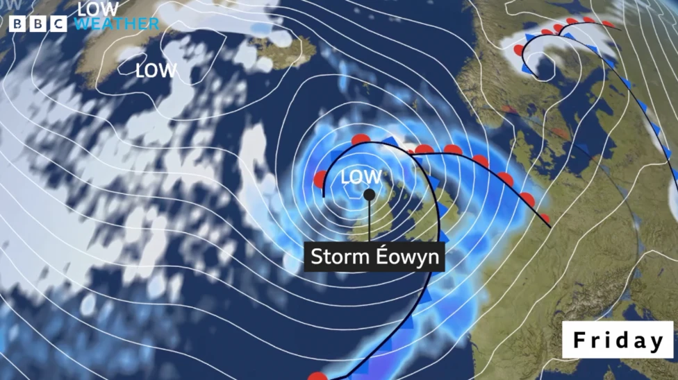
Storm Éowyn – pronounced "ay-oh-win" – will undergo rapid development during Thursday as it moves across the Atlantic
While some of the details may still change, depending on the exact track Éowyn takes in the UK, the strongest winds on Friday are likely across parts of Northern Ireland, southern Scotland, northern and western areas of England and Wales.
The Met Office warns of gusts between 80-90mph (129-145km/h) around hills coastal areas of the Irish Sea. But widely gusts of 60-70mph (97-113km/h) are expected through the day. Elsewhere, across northern and western Scotland, parts of the Midlands and southern England, gusts of 50-65mph (80-105km/h) are expected but around coastal areas up to 80mph (129km/h). Met Office yellow warnings are likely to be adjusted and possibly upgraded ahead of Friday.
These gales and severe gales are likely to bring travel disruption and some damage, which could include roof tiles being blown off and power cuts. Large waves are also expected with coastal overtopping. Outbreaks of rain are also expected and while it will turn milder for some - especially in the south - it will remain cold enough for snow to fall over hills in Scotland, northern England and Northern Ireland.
The Met Office has issued a yellow warning for wind on Friday and Saturday. Gusts of up to 90mph (145km/h) - or possibly even more - could bring localised damage, power cuts and travel disruption. Heavy rain and hill snow are also expected. It will mark a big change from the quiet and rather cold weather that has dominated over the last week or so.
Storm Éowyn – pronounced "ay-oh-win" – will undergo rapid development during Thursday as it moves across the Atlantic
While some of the details may still change, depending on the exact track Éowyn takes in the UK, the strongest winds on Friday are likely across parts of Northern Ireland, southern Scotland, northern and western areas of England and Wales.
The Met Office warns of gusts between 80-90mph (129-145km/h) around hills coastal areas of the Irish Sea. But widely gusts of 60-70mph (97-113km/h) are expected through the day. Elsewhere, across northern and western Scotland, parts of the Midlands and southern England, gusts of 50-65mph (80-105km/h) are expected but around coastal areas up to 80mph (129km/h). Met Office yellow warnings are likely to be adjusted and possibly upgraded ahead of Friday.
These gales and severe gales are likely to bring travel disruption and some damage, which could include roof tiles being blown off and power cuts. Large waves are also expected with coastal overtopping. Outbreaks of rain are also expected and while it will turn milder for some - especially in the south - it will remain cold enough for snow to fall over hills in Scotland, northern England and Northern Ireland.
Please, be aware and take care out there. Chris.

| Re: Warnings of snow, wind and rain across the UK for New Year Posted by Chris from Nailsea at 16:39, 8th January 2025 | |
An update, from the BBC:
Cold snap grips UK as -20C possible overnight
Wintry weather is tightening its grip in many parts of the UK, with sub-zero temperatures expected to plunge even lower overnight and more snow forecast in some places.
Forecasters predict the coldest nights of the year over the next two days, and temperatures are expected to fall as low as -20C in some places that endured heavy snowfall at the weekend.
A fresh amber warning for snow has come into force in the South West, with yellow snow and ice warnings also in place for other parts of the UK into Thursday.
There are also 75 flood warnings, meaning flooding is expected, and 148 flood alerts, meaning flooding is possible, in place across England. One flood warning and four flood alerts are in force in Wales. There are no severe flood warnings in place, which indicate a danger to life or significant disruption. Looking ahead, the flooding and warnings are expected to reduce with no significant rain predicted in the areas experiencing flooding.
An amber cold health alert - the second-highest level - covering all regions of England is in place until midday on Sunday. The alert, issued by the UK Health Security Agency (UKHSA), warns the freezing conditions are likely to result in a rise in deaths, particularly among older and vulnerable people, and an increase in demand for health services. They are different to weather warnings and provide early warning to healthcare providers, and suggest actions such as actively monitoring individuals at a high risk.
Dr Agostinho Sousa from the UKHSA said it was vital to check in on vulnerable people who could be "more at risk of heart attacks, stroke and chest infections as a result of cold temperatures".
Some people are entitled to cold weather payments to help with fuel bills. Eleven thousand people in England are estimated to have received the top-up since November ...
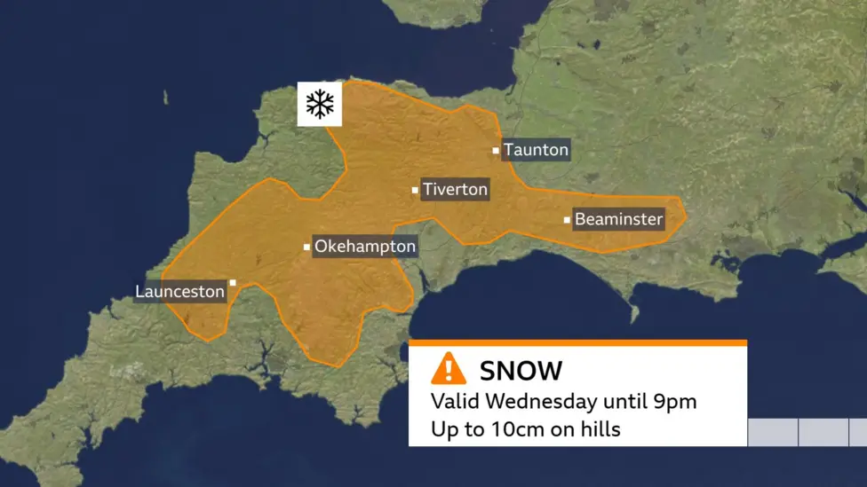
An amber warning for snow covering Cornwall, Devon, Dorset and Somerset is set to last until 21:00 GMT on Wednesday.
Isolated yellow snow and ice warnings spanning Wednesday and Thursday are in place across the UK, including parts of Northern Ireland and the Scottish Highlands, although their coverage is not as wide as in recent days.
Yellow warnings have also been issued for Wales and other parts of South West England from 03:00 GMT until 12:00 GMT on Thursday.
Rain will spread across the far south of England but there will be some snow over Exmoor and Dartmoor, perhaps as much as 10cm (4in) on Wednesday.
Snow may also fall over mainly higher ground later on Wednesday in south-east England. The focus will switch to how far temperatures are likely to fall, particularly during the night.
Temperatures on Tuesday night widely fell below freezing, with most of the UK waking up on Wednesday to a frost. The lowest temperature overnight was in Scotland with -7C at Tulloch Bridge. But with -6.9C in Katesbridge, it was Northern Ireland's coldest night of the winter so far.
Across England, the temperature fell to -8.4C in Shap, Cumbria, but even in southern England it was -6.1C at Benson, Oxfordshire.
In Wales, the lowest temperature was -3.8C in Bala, Gwynedd.
The wintry conditions have caused significant disruption across the UK since snow swept many parts of the country at the weekend.
Hundreds of schools were closed in England, Scotland and Northern Ireland, including schools in Yorkshire, Merseyside, the Midlands and Aberdeenshire.
Extensive flooding caused some local roads to remain shut on Wednesday in Lincolnshire, while Northern Rail also confirmed no services would stop at Gathurst station near Wigan.
Most flights are running again after they were temporarily halted at airports in Liverpool, Bristol, Aberdeen and Manchester - but operators have warned some delays are still likely.
Bitter cold is expected in many parts of the UK in the coming days, with the likelihood of sharp overnight frosts. Temperatures are expected to drop well below freezing on Wednesday and Thursday night, with forecasters expecting many parts of the UK to experience a hard frost and lows of between -3C and -10C.
In places that are still experiencing snow cover, it could be as cold as -14C to -16C on Wednesday night, and on Thursday the Pennines and snow fields of Scotland could register temperatures as low as -16C to -20C. That would actually be far colder than was experienced at the weekend when a low of -13.3 C was recorded at Loch Glascarnoch in the Highlands. It is also significantly lower than anything seen last winter when a particularly bitter night in Dalwhinnie in the Highlands saw a mark of -14C being recorded.
The last time the UK had any temperature below -20C was in February 2021 when Braemar in Aberdeenshire was measured at -23C.
Wintry weather is tightening its grip in many parts of the UK, with sub-zero temperatures expected to plunge even lower overnight and more snow forecast in some places.
Forecasters predict the coldest nights of the year over the next two days, and temperatures are expected to fall as low as -20C in some places that endured heavy snowfall at the weekend.
A fresh amber warning for snow has come into force in the South West, with yellow snow and ice warnings also in place for other parts of the UK into Thursday.
There are also 75 flood warnings, meaning flooding is expected, and 148 flood alerts, meaning flooding is possible, in place across England. One flood warning and four flood alerts are in force in Wales. There are no severe flood warnings in place, which indicate a danger to life or significant disruption. Looking ahead, the flooding and warnings are expected to reduce with no significant rain predicted in the areas experiencing flooding.
An amber cold health alert - the second-highest level - covering all regions of England is in place until midday on Sunday. The alert, issued by the UK Health Security Agency (UKHSA), warns the freezing conditions are likely to result in a rise in deaths, particularly among older and vulnerable people, and an increase in demand for health services. They are different to weather warnings and provide early warning to healthcare providers, and suggest actions such as actively monitoring individuals at a high risk.
Dr Agostinho Sousa from the UKHSA said it was vital to check in on vulnerable people who could be "more at risk of heart attacks, stroke and chest infections as a result of cold temperatures".
Some people are entitled to cold weather payments to help with fuel bills. Eleven thousand people in England are estimated to have received the top-up since November ...
An amber warning for snow covering Cornwall, Devon, Dorset and Somerset is set to last until 21:00 GMT on Wednesday.
Isolated yellow snow and ice warnings spanning Wednesday and Thursday are in place across the UK, including parts of Northern Ireland and the Scottish Highlands, although their coverage is not as wide as in recent days.
Yellow warnings have also been issued for Wales and other parts of South West England from 03:00 GMT until 12:00 GMT on Thursday.
Rain will spread across the far south of England but there will be some snow over Exmoor and Dartmoor, perhaps as much as 10cm (4in) on Wednesday.
Snow may also fall over mainly higher ground later on Wednesday in south-east England. The focus will switch to how far temperatures are likely to fall, particularly during the night.
Temperatures on Tuesday night widely fell below freezing, with most of the UK waking up on Wednesday to a frost. The lowest temperature overnight was in Scotland with -7C at Tulloch Bridge. But with -6.9C in Katesbridge, it was Northern Ireland's coldest night of the winter so far.
Across England, the temperature fell to -8.4C in Shap, Cumbria, but even in southern England it was -6.1C at Benson, Oxfordshire.
In Wales, the lowest temperature was -3.8C in Bala, Gwynedd.
The wintry conditions have caused significant disruption across the UK since snow swept many parts of the country at the weekend.
Hundreds of schools were closed in England, Scotland and Northern Ireland, including schools in Yorkshire, Merseyside, the Midlands and Aberdeenshire.
Extensive flooding caused some local roads to remain shut on Wednesday in Lincolnshire, while Northern Rail also confirmed no services would stop at Gathurst station near Wigan.
Most flights are running again after they were temporarily halted at airports in Liverpool, Bristol, Aberdeen and Manchester - but operators have warned some delays are still likely.
Bitter cold is expected in many parts of the UK in the coming days, with the likelihood of sharp overnight frosts. Temperatures are expected to drop well below freezing on Wednesday and Thursday night, with forecasters expecting many parts of the UK to experience a hard frost and lows of between -3C and -10C.
In places that are still experiencing snow cover, it could be as cold as -14C to -16C on Wednesday night, and on Thursday the Pennines and snow fields of Scotland could register temperatures as low as -16C to -20C. That would actually be far colder than was experienced at the weekend when a low of -13.3 C was recorded at Loch Glascarnoch in the Highlands. It is also significantly lower than anything seen last winter when a particularly bitter night in Dalwhinnie in the Highlands saw a mark of -14C being recorded.
The last time the UK had any temperature below -20C was in February 2021 when Braemar in Aberdeenshire was measured at -23C.
| Re: Warnings of snow, wind and rain across the UK for New Year Posted by UstiImmigrunt at 14:36, 7th January 2025 | |
It's elf and safety gone mad! 
https://www.msn.com/en-gb/public-safety-and-emergencies/health-and-safety-alerts/trains-cancelled-after-union-tells-drivers-not-to-walk-on-snow/ar-AA1x3ATg?ocid=msedgntp&pc=U531&cvid=a6adf81109604cd5ba970c70a324f18c&ei=26
https://www.msn.com/en-gb/public-safety-and-emergencies/health-and-safety-alerts/trains-cancelled-after-union-tells-drivers-not-to-walk-on-snow/ar-AA1x3ATg?ocid=msedgntp&pc=U531&cvid=a6adf81109604cd5ba970c70a324f18c&ei=26
One has to ask how did the drivers even manage to get to the depot if it was unsafe?
Are the union going to ask each council/company to clear all paths/roads of snow before drivers can leave their house?
I wouldn't laugh too much. Far too many drivers and guards have no idea how to walk on ballast either, so what chances of being able to walk on ice and or snow?
Whilst instructing I asked my DSM if it was possible to use a SPT rather than the SG button on the GSMR. The answer, no. Because if the trainee sprained an ankle it would be my fault. So only those who work on SPM definitely and maybe Gloucester, Westbury or Laira would know how to walk on ballast. Everywhere has a lovely walking route installed.
I've spent more time walking on the ballast of České Dráhy in the last 3 months than the last 5 and a bit years in work. In May 2018 I visited SPM for the final time, that was my last ballast walk.
PS Currently having a few nights around Bern, plenty of snow and I'm being very careful in my walking around.
| Re: Warnings of snow, wind and rain across the UK for New Year Posted by GBM at 10:35, 7th January 2025 | |
I was suffiiciently impressed by the ridges on the footpath crossing over the main line to take photos


Good to see Melksham is now double tracked.At last

| Re: Warnings of snow, wind and rain across the UK for New Year Posted by grahame at 10:18, 7th January 2025 | |
I was suffiiciently impressed by the ridges on the footpath crossing over the main line to take photos
| Re: Warnings of snow, wind and rain across the UK for New Year Posted by stuving at 09:53, 7th January 2025 | |
It's elf and safety gone mad!
https://www.msn.com/en-gb/public-safety-and-emergencies/health-and-safety-alerts/trains-cancelled-after-union-tells-drivers-not-to-walk-on-snow/ar-AA1x3ATg?ocid=msedgntp&pc=U531&cvid=a6adf81109604cd5ba970c70a324f18c&ei=26
https://www.msn.com/en-gb/public-safety-and-emergencies/health-and-safety-alerts/trains-cancelled-after-union-tells-drivers-not-to-walk-on-snow/ar-AA1x3ATg?ocid=msedgntp&pc=U531&cvid=a6adf81109604cd5ba970c70a324f18c&ei=26
One has to ask how did the drivers even manage to get to the depot if it was unsafe?
Are the union going to ask each council/company to clear all paths/roads of snow before drivers can leave their house?
That does remind me of something: the recent trend for surfacing walking routes to sidings with manufactured panels. These look to be made of some plastic, but whatever it is it also looks as if it would be pretty slippery when wet, let alone covered in a thin layer of snow. So maybe there is a real issue behind this; smoother paths need more anti-slip and snow-clearing procedures.
That would be of a piece with our local council, who repaved the footpath along the main road outside their offices with some rather glazed pink blocks. It's on a slope, and broken leg or two later the paving was torn up and replaced with something grippier.
| Re: Warnings of snow, wind and rain across the UK for New Year Posted by ray951 at 08:18, 7th January 2025 | |
It's elf and safety gone mad!
https://www.msn.com/en-gb/public-safety-and-emergencies/health-and-safety-alerts/trains-cancelled-after-union-tells-drivers-not-to-walk-on-snow/ar-AA1x3ATg?ocid=msedgntp&pc=U531&cvid=a6adf81109604cd5ba970c70a324f18c&ei=26
https://www.msn.com/en-gb/public-safety-and-emergencies/health-and-safety-alerts/trains-cancelled-after-union-tells-drivers-not-to-walk-on-snow/ar-AA1x3ATg?ocid=msedgntp&pc=U531&cvid=a6adf81109604cd5ba970c70a324f18c&ei=26
One has to ask how did the drivers even manage to get to the depot if it was unsafe?
Are the union going to ask each council/company to clear all paths/roads of snow before drivers can leave their house?
| Re: Warnings of snow, wind and rain across the UK for New Year Posted by TaplowGreen at 07:11, 7th January 2025 | |
It's elf and safety gone mad!
https://www.msn.com/en-gb/public-safety-and-emergencies/health-and-safety-alerts/trains-cancelled-after-union-tells-drivers-not-to-walk-on-snow/ar-AA1x3ATg?ocid=msedgntp&pc=U531&cvid=a6adf81109604cd5ba970c70a324f18c&ei=26
| Re: Warnings of snow, wind and rain across the UK for New Year Posted by ChrisB at 11:03, 6th January 2025 | |
New yellow warnings issujed for some of our area tonight & tomorrow morning & Wednesday now too
| Re: Warnings of snow, wind and rain across the UK for New Year Posted by Chris from Nailsea at 23:06, 5th January 2025 | |
| Re: Warnings of snow, wind and rain across the UK for New Year Posted by Chris from Nailsea at 22:17, 3rd January 2025 | |
I'm not going to even try to quote anything specific from this BBC item - it's being updated continuously.
Please: let's all be careful out there!
Chris.
| Warnings of snow, wind and rain across the UK for January 2025 Posted by Chris from Nailsea at 15:47, 29th December 2024 | |
From the BBC:
Weather warnings for rain, snow and winds of up to 70mph have been issued for parts of the UK on New Year's Eve and New Year's Day, the Met Office has said.
Yellow warnings are in place for Northern Ireland, northern England and parts of Scotland from Tuesday before extending across most of the UK on Wednesday.
A series of warnings begin to come into force from 00:00 GMT on Monday and will last in some areas until 06:00 GMT on 2 January.
The forecaster said there was likely to be travel disruption with almost all of the country impacted by at least one yellow alert over the four days.
Following a period of heavy rain and some hill snow in Scotland on Monday, two areas of low pressure will bring unsettled conditions on both New Year's Eve and New Year's Day and eventually lead to a cold plunge of air from the north and a drop in temperature.
On New Year's Eve, there could be as much as 100-140mm (3.9- 5.5 inches) of rainfall in some parts of western Scotland which could lead to localised flooding. There could be some further snow in northern parts of the country too.
There will also be spells of rain across England, Northern Ireland and Wales. The rain looks particularly heavy in Wales.
While it will be windy everywhere, it could be very blustery in the south of England as the new year is welcomed in.
The weather warnings in place across the UK include:
- In northern Scotland, a yellow warning for rain and snow from 00:00 GMT on Monday until midnight on Tuesday. A separate warning for snow is in place for the Orkney Islands from 05:00 GMT until midnight on Tuesday.
- Also on Tuesday, parts of northern England are covered by a yellow warning for wind from 07:00 GMT until 23:00 GMT. A separate wind warning covers Northern Ireland from 06:00 GMT until 19:00 GMT.
- On Wednesday, yellow warnings for snow come into force, covering Northern Ireland until midnight and parts of northern England until 03:00 GMT on Thursday.
- Also on Wednesday, a yellow warning for wind is in place for most of England from 09:00 GMT until 06:00 GMT on Thursday. A separate yellow warning for rain covers part of Wales from 09:00 GMT until 21:00 GMT.
More widespread disruption is expected on New Year's Day as another area of low pressure moves across the UK.
The strongest winds will be over England and Wales with gusts near 70mph over coasts and hills in the south and west.
Rain is forecast to be heavier in Wales on Wednesday, which could bring some flooding.
Possible snowfall may lead to disruption in Northern Ireland, Scotland and northern England.
Forecasters said 10cm of snow was expected in some areas with heavier falls over hills with blizzards and drifting.
The Met Office said there was "potential for the pattern of warnings to shift and possibly escalate in some areas".
Those travelling and with plans over the New Year are being urged to check the latest forecasts.
The yellow weather warnings come after thick fog caused disruption to hundreds of flights at some of the UK's major airports over the weekend.
Gatwick Airport reported continued delays on Sunday, and flights at Manchester, Glasgow and Cardiff were also affected on Friday and Saturday due to poor visibility.
Disruption could continue on Wednesday night. By the morning of Thursday 2 January, as the area of low pressure clears into Europe, arctic air may sweep towards the UK.
From Thursday into next weekend it will be much colder everywhere with widespread frosts. Most places will be dry and sunny during the day but wintry showers will affect northern areas and lead to icy conditions.
