







| Re: Bristol Tramways Posted by Mark A at 14:58, 24th October 2026 |     |
Since I was attending a meeting to make a point about intermodal change at major stations... those Bristol Temple Meads tram rails leapt out at me. Many people are familiar with them but less familiar with their purpose - I attempted to reconstruct the passenger experience at the terminus in my minds eye, and wondered at the same time how the spur was worked... and realised that all this was in use for long enough for the track layout there to evolve, perhaps at the time the system was electrified. In the horse drawn era, two tracks, a short spur off the route to... Brislington(?) converge to a single line along a platform - with an overall roof, and a waiting room.
Later, with the system electrified, the remains on the ground indicate that the temple meads tram track had been doubled and perhaps other changes made. This switch is on the inward (headshunt) end of the tram station tracks [Update, it's possibly the one in this pre WW1 25" map. https://maps.nls.uk/geo/explore/#zoom=18.9&lat=51.44920&lon=-2.58282&layers=168&b=GoogleSat&o=100 ].
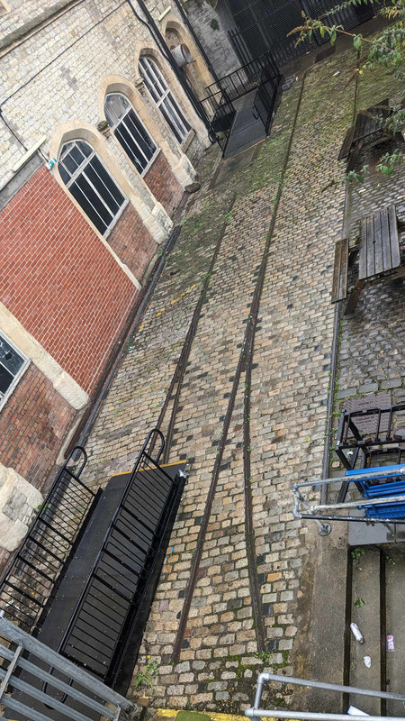
As I was pondering this, an electric No 8 bus passed to make its booked stop beyond the station approach. Curiously I've just found that the electrified trams were numbered, and it was the number 8 tram that ran between the Temple Meads terminus and the city centre. Perhaps the bus to Clifton is its distant descendant. I did discover that the Temple Meads tram station wasn't regarded as a operational inconvenience, it was in use until the Nazis wounded its infrastructure in April '41 and the decision was made to kill the entire system off.
In due course, over a year later, with the tram system gone, it was a group of internal combustion powered buses and passengers that received a direct hit from a 250Kg bomb dropped from 25000 feet from a lone German aircraft, killing more than two score people.
https://www.bbc.co.uk/history/ww2peopleswar/stories/25/a5382425.shtml
Something that isn't clear is the walking route for passengers between the trains and the trams. Down the ramp is one option, but was there a covered route to the tram station at the level of the station vaults? The map somewhat hints that there was - why so much roof above the tram stop headshunt otherwise?
| Re: Bristol Tramways Posted by Bmblbzzz at 21:25, 28th September 2019 | |
If you'll forgive a distraction from trams for a second, some rails from the former Clifton Down coal yard are still visible in Alma Vale Road. It's hard to make them out on Street View but I think you can just about see a small length of one in the middle of the road here: https://www.google.com/maps/@51.4636443,-2.611672,3a,75y,265.33h,75.3t/data=!3m6!1e1!3m4!1sNHcsFNZOSY0chorAifY2yA!2e0!7i13312!8i6656
They're much more obvious in real life.
| Re: Bristol Tramways Posted by Red Squirrel at 15:12, 28th September 2019 | |
Image No.1 in the Bristol 247 piece is at Clifton Down Station - the single-story shops backed onto the coal yard where later the Clifton Down Shopping Centre was built, doing the architectural equivalent of mooning at the station platforms.
Eastville Tram depot is largely intact, though it's easier to make it out from the air (see here https://goo.gl/maps/qmFNoatZ3KyXxf8CA ) than from Fishponds Road owing to a seventies building blocking the view (https://goo.gl/maps/rnWst9EsnE9M8zAA7)
Staple Hill depot is much easier to spot: https://goo.gl/maps/5woNgtnFDAtH9Mxe6
Horfield depot is, as johnneyw points out, now Gloucester Rd Medical Centre; you can see the tracks in the car park ( https://goo.gl/maps/suv64CJW7WK7xUGx8 ). The building to the north of the fossil fuelling station was part of the depot complex.
| Re: Bristol Tramways Posted by TonyK at 14:45, 28th September 2019 | |
Hiding in plain sight is the former tram depot at the junction of Sandy Park Road, Bloomfield Road, and the A4 Bath Road, at Arnos Vale. The Bristol and North Somerset line ran through the rear of the now council depot.

(c) Me, but feel free to use after contacting me for the appropriate attribution.
There are some lovely pictures in this Bristol 24/7 article.
There is a picture of the tram depot in its heyday here - the sheds are still visible in my photo above. There is another of a tram outside the depot here.
...and of course the length of rail embedded end-on in St Mary Redcliffe churchyard, where a high explosive bomb planted it.
This was a different bomb from the one that blew up the bridge in Counterslip, although part of the same raid on Good Friday 1941, and possibly from the same aircraft. It hit somewhere around Bedminster Bridge, and the rail travelled through the air for around 400 yards before reaching its current spot. It proved easier to make it a memorial than to dig it out, and there are pictures here.| Re: Bristol Tramways Posted by Bmblbzzz at 13:57, 28th September 2019 | |
Not to mention the rails and steps outside what is now Zero Degrees at the top of Colston St. And the old tram shed near Page Park. And others.
| Re: Bristol Tramways Posted by johnneyw at 13:54, 28th September 2019 | |
...and of course the length of rail embedded end-on in St Mary Redcliffe churchyard, where a high explosive bomb planted it.
Blimey, you learn something new every day. Added to my 'next time in town' and 'did you know?' lists.
| Re: Bristol Tramways Posted by Red Squirrel at 12:28, 28th September 2019 | |
...and of course the length of rail embedded end-on in St Mary Redcliffe churchyard, where a high explosive bomb planted it.
When they built the Temple Meads tram terminal, part of the facade of the old station was demolished; you can see that it is no longer symmetrical. Wouldn't get away with that now!
| Re: Bristol Tramways Posted by johnneyw at 12:24, 28th September 2019 | |
There are remnants of the Bristol tram system still visible in the car parking area of the Gloucester Road Health Centre. Original rails were retained on the site of the old tram depot as a reminder of it's former use.
| Bristol Tramways Posted by grahame at 11:27, 28th September 2019 | |
I have oft wondered about the rails in the yard outside "Platform 14" at the base of the incline up to Bristol Temple Meads Station, and a few 'spare' minutes this morning lead me to researching them ... turns out (according to sources I have not verified) that they were part of the Bristol tramway network.
The first trams in Bristol (horse-drawn, with a maximum speed of 6 miles per hour) were introduced in 1875. Electric trams were introduced in 1895, the first city to do so in the United Kingdom. At the system's peak there were 17 routes and 237 tramcars in use.
Abandonment of the tramways began in 1938, but this was halted at the outbreak of World War II. Tram operations ceased in 1941 following the Luftwaffe's Good Friday air raids during the Bristol Blitz, which set central Bristol on fire. A bomb hit Counterslip bridge, St Philips, next to the Tramways generating centre, and severed the tram power supply. The final tram from Old Market to Kingswood was given a push by passers-by and freewheeled its way into the depot.
Above from Wikipedia which includes a map and much more.
Edit to add - also at http://wpehs.org.uk/bristol-tramways which includes similar wording

