Train GraphicClick on the map to explore geographics
 
I need help
FAQ
Emergency
About .
No recent travel & transport from BBC stories as at 07:35 05 Feb 2025
Read about the forum [here].
Register [here] - it's free.
What do I gain from registering? [here]
 12/02/25 - TWSW Integrated Webinar
15/02/25 - Special Bletchey to Bicester
20/02/25 - Integrated Transport Strategy
06/03/25 - Go-op Crowd Funding closes

On this day
5th Feb (1971)
Foundation meeting, heritage railway to Minehead (link)

Train RunningCancelled
07:20 Portsmouth Harbour to Cardiff Central
07:24 Exmouth to Paignton
Short Run
05:56 Paignton to Exmouth
06:52 Newbury to London Paddington
06:55 Exmouth to Paignton
07:33 Weymouth to Gloucester
07:54 Exmouth to Paignton
09:16 Paignton to Exmouth
Delayed
An additional train service has been planned to operate as shown 07:30 Exeter St Davids to Paignton
PollsOpen and recent polls
Open to 06/02 21:00 Which of these do you agree with?
Abbreviation pageAcronymns and abbreviations
Stn ComparatorStation Comparator
Rail newsNews Now - live rail news feed
Site Style 1 2 3 4
Next departures • Bristol Temple MeadsBath SpaChippenhamSwindonDidcot ParkwayReadingLondon PaddingtonMelksham
Exeter St DavidsTauntonWestburyTrowbridgeBristol ParkwayCardiff CentralOxfordCheltenham SpaBirmingham New Street
February 05, 2025, 07:51:44 *
Welcome, Guest. Please login or register.

Login with username, password and session length
Forgotten your username or password? - get a reminder
Most recently liked subjects
[97] Greatest Gathering - 1st to 3rd August 2025
[69] Stop using the word ‘passenger’, Network Rail tells staff
[49] Bristol Temple Meads - station, facilities, incidents and even...
[39] Vibrant or dangerous? Colourful roundabout redesign divides vi...
[36] Bristol artwork celebrates Brunel's pop-up Crimean hospital
[34] Landslips and landslides on the transport networks
 
News: the Great Western Coffee Shop ... keeping you up to date with travel around the South West
 
   Home   Help Search Calendar Login Register  
Pages: [1] 2
  Print  
Author Topic: Warnings of snow, wind and rain across the UK for January 2025  (Read 2731 times)
Chris from Nailsea
Administrator
Hero Member
*****
Posts: 19221


Justice for Cerys Piper and Theo Griffiths please!


View Profile Email
« on: December 29, 2024, 15:47:44 »

From the BBC» (British Broadcasting Corporation - home page):

Quote

Weather warnings for rain, snow and winds of up to 70mph have been issued for parts of the UK (United Kingdom) on New Year's Eve and New Year's Day, the Met Office has said.

Yellow warnings are in place for Northern Ireland, northern England and parts of Scotland from Tuesday before extending across most of the UK on Wednesday.

A series of warnings begin to come into force from 00:00 GMT on Monday and will last in some areas until 06:00 GMT on 2 January.

The forecaster said there was likely to be travel disruption with almost all of the country impacted by at least one yellow alert over the four days.

Following a period of heavy rain and some hill snow in Scotland on Monday, two areas of low pressure will bring unsettled conditions on both New Year's Eve and New Year's Day and eventually lead to a cold plunge of air from the north and a drop in temperature.

On New Year's Eve, there could be as much as 100-140mm (3.9- 5.5 inches) of rainfall in some parts of western Scotland which could lead to localised flooding. There could be some further snow in northern parts of the country too.

There will also be spells of rain across England, Northern Ireland and Wales. The rain looks particularly heavy in Wales.

While it will be windy everywhere, it could be very blustery in the south of England as the new year is welcomed in.

The weather warnings in place across the UK include:

- In northern Scotland, a yellow warning for rain and snow from 00:00 GMT on Monday until midnight on Tuesday. A separate warning for snow is in place for the Orkney Islands from 05:00 GMT until midnight on Tuesday.

- Also on Tuesday, parts of northern England are covered by a yellow warning for wind from 07:00 GMT until 23:00 GMT. A separate wind warning covers Northern Ireland from 06:00 GMT until 19:00 GMT.

- On Wednesday, yellow warnings for snow come into force, covering Northern Ireland until midnight and parts of northern England until 03:00 GMT on Thursday.

- Also on Wednesday, a yellow warning for wind is in place for most of England from 09:00 GMT until 06:00 GMT on Thursday. A separate yellow warning for rain covers part of Wales from 09:00 GMT until 21:00 GMT.

More widespread disruption is expected on New Year's Day as another area of low pressure moves across the UK.

The strongest winds will be over England and Wales with gusts near 70mph over coasts and hills in the south and west.

Rain is forecast to be heavier in Wales on Wednesday, which could bring some flooding.

Possible snowfall may lead to disruption in Northern Ireland, Scotland and northern England.

Forecasters said 10cm of snow was expected in some areas with heavier falls over hills with blizzards and drifting.

The Met Office said there was "potential for the pattern of warnings to shift and possibly escalate in some areas".

Those travelling and with plans over the New Year are being urged to check the latest forecasts.

The yellow weather warnings come after thick fog caused disruption to hundreds of flights at some of the UK's major airports over the weekend.

Gatwick Airport reported continued delays on Sunday, and flights at Manchester, Glasgow and Cardiff were also affected on Friday and Saturday due to poor visibility.

Disruption could continue on Wednesday night. By the morning of Thursday 2 January, as the area of low pressure clears into Europe, arctic air may sweep towards the UK.

From Thursday into next weekend it will be much colder everywhere with widespread frosts. Most places will be dry and sunny during the day but wintry showers will affect northern areas and lead to icy conditions.


« Last Edit: January 27, 2025, 20:43:15 by Chris from Nailsea » Logged

William Huskisson MP (Member of Parliament) was the first person to be killed by a train while crossing the tracks, in 1830.  Many more have died in the same way since then.  Don't take a chance: stop, look, listen.

"Level crossings are safe, unless they are used in an unsafe manner."  Discuss.
Chris from Nailsea
Administrator
Hero Member
*****
Posts: 19221


Justice for Cerys Piper and Theo Griffiths please!


View Profile Email
« Reply #1 on: January 03, 2025, 22:17:01 »

I'm not going to even try to quote anything specific from this BBC» (British Broadcasting Corporation - home page) item - it's being updated continuously.

Please: let's all be careful out there!  Lips sealed

Chris.
Logged

William Huskisson MP (Member of Parliament) was the first person to be killed by a train while crossing the tracks, in 1830.  Many more have died in the same way since then.  Don't take a chance: stop, look, listen.

"Level crossings are safe, unless they are used in an unsafe manner."  Discuss.
Chris from Nailsea
Administrator
Hero Member
*****
Posts: 19221


Justice for Cerys Piper and Theo Griffiths please!


View Profile Email
« Reply #2 on: January 05, 2025, 23:06:33 »

Please, do continue to read these ongoing updates, from the BBC» (British Broadcasting Corporation - home page).  Roll Eyes
Logged

William Huskisson MP (Member of Parliament) was the first person to be killed by a train while crossing the tracks, in 1830.  Many more have died in the same way since then.  Don't take a chance: stop, look, listen.

"Level crossings are safe, unless they are used in an unsafe manner."  Discuss.
ChrisB
Transport Scholar
Hero Member
******
Posts: 13100


View Profile Email
« Reply #3 on: January 06, 2025, 11:03:16 »

New yellow warnings issujed for some of our area tonight & tomorrow morning & Wednesday now too
Logged
TaplowGreen
Transport Scholar
Hero Member
******
Posts: 8484


View Profile
« Reply #4 on: January 07, 2025, 07:11:05 »

It's elf and safety gone mad!  Wink

https://www.msn.com/en-gb/public-safety-and-emergencies/health-and-safety-alerts/trains-cancelled-after-union-tells-drivers-not-to-walk-on-snow/ar-AA1x3ATg?ocid=msedgntp&pc=U531&cvid=a6adf81109604cd5ba970c70a324f18c&ei=26
Logged
ray951
Transport Scholar
Hero Member
******
Posts: 506


View Profile
« Reply #5 on: January 07, 2025, 08:18:31 »


One has to ask how did the drivers even manage to get to the depot if it was unsafe?
Are the union going to ask each council/company to clear all paths/roads of snow before drivers can leave their house?
Logged
stuving
Transport Scholar
Hero Member
******
Posts: 7384


View Profile
« Reply #6 on: January 07, 2025, 09:53:05 »


One has to ask how did the drivers even manage to get to the depot if it was unsafe?
Are the union going to ask each council/company to clear all paths/roads of snow before drivers can leave their house?

That does remind me of something: the recent trend for surfacing walking routes to sidings with manufactured panels. These look to be made of some plastic, but whatever it is it also looks as if it would be pretty slippery when wet, let alone covered in a thin layer of snow. So maybe there is a real issue behind this; smoother paths need more anti-slip and snow-clearing procedures.

That would be of a piece with our local council, who repaved the footpath along the main road outside their offices with some rather glazed pink blocks. It's on a slope, and broken leg or two later the paving was torn up and replaced with something grippier.
Logged
grahame
Administrator
Hero Member
*****
Posts: 43253


View Profile WWW Email
« Reply #7 on: January 07, 2025, 10:18:21 »

I was suffiiciently impressed by the ridges on the footpath crossing over the main line to take photos


Logged

Coffee Shop Admin, Chair of Melksham Rail User Group, TravelWatch SouthWest Board Member
GBM
Transport Scholar
Hero Member
******
Posts: 1705


View Profile Email
« Reply #8 on: January 07, 2025, 10:35:52 »

I was suffiiciently impressed by the ridges on the footpath crossing over the main line to take photos


Good to see Melksham is now double tracked.
At last  Grin Grin
Logged

Personal opinion only.  Writings not representative of any union, collective, management or employer. (Think that absolves me...........)
UstiImmigrunt
Full Member
***
Posts: 66


View Profile
« Reply #9 on: January 07, 2025, 14:36:41 »


One has to ask how did the drivers even manage to get to the depot if it was unsafe?
Are the union going to ask each council/company to clear all paths/roads of snow before drivers can leave their house?

I wouldn't laugh too much. Far too many drivers and guards have no idea how to walk on ballast either, so what chances of being able to walk on ice and or snow?

Whilst instructing I asked my DSM if it was possible to use a SPT (Signal Post Telephone) rather than the SG button on the GSMR. The answer, no. Because if the trainee sprained an ankle it would be my fault. So only those who work on SPM (St Philip's Marsh (Bristol depot)) definitely and maybe Gloucester, Westbury or Laira would know how to walk on ballast. Everywhere has a lovely walking route installed.

I've spent more time walking on the ballast of České Dráhy in the last 3 months than the last 5 and a bit years in work. In May 2018 I visited SPM for the final time, that was my last ballast walk.

PS Currently having a few nights around Bern, plenty of snow and I'm being very careful in my walking around.
Logged

Retired and loving it!

Pround owner of a brand new little red book and an annual first class https://oneticket.cz/networkPassSearch

It will be well used and I doubt I'll ever get any delay repay compensation.
Chris from Nailsea
Administrator
Hero Member
*****
Posts: 19221


Justice for Cerys Piper and Theo Griffiths please!


View Profile Email
« Reply #10 on: January 08, 2025, 16:39:08 »

An update, from the BBC» (British Broadcasting Corporation - home page):

Quote
Cold snap grips UK (United Kingdom) as -20C possible overnight

Wintry weather is tightening its grip in many parts of the UK, with sub-zero temperatures expected to plunge even lower overnight and more snow forecast in some places.

Forecasters predict the coldest nights of the year over the next two days, and temperatures are expected to fall as low as -20C in some places that endured heavy snowfall at the weekend.

A fresh amber warning for snow has come into force in the South West, with yellow snow and ice warnings also in place for other parts of the UK into Thursday.

There are also 75 flood warnings, meaning flooding is expected, and 148 flood alerts, meaning flooding is possible, in place across England.  One flood warning and four flood alerts are in force in Wales. There are no severe flood warnings in place, which indicate a danger to life or significant disruption.  Looking ahead, the flooding and warnings are expected to reduce with no significant rain predicted in the areas experiencing flooding.

An amber cold health alert - the second-highest level - covering all regions of England is in place until midday on Sunday.  The alert, issued by the UK Health Security Agency (UKHSA), warns the freezing conditions are likely to result in a rise in deaths, particularly among older and vulnerable people, and an increase in demand for health services.  They are different to weather warnings and provide early warning to healthcare providers, and suggest actions such as actively monitoring individuals at a high risk.

Dr Agostinho Sousa from the UKHSA said it was vital to check in on vulnerable people who could be "more at risk of heart attacks, stroke and chest infections as a result of cold temperatures".

Some people are entitled to cold weather payments to help with fuel bills. Eleven thousand people in England are estimated to have received the top-up since November ...


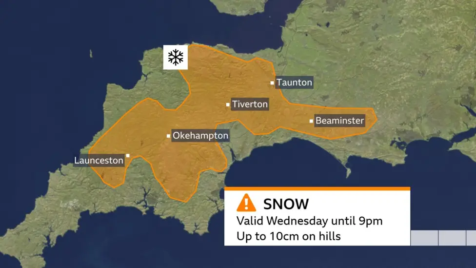
An amber warning for snow covering Cornwall, Devon, Dorset and Somerset is set to last until 21:00 GMT on Wednesday.

Isolated yellow snow and ice warnings spanning Wednesday and Thursday are in place across the UK, including parts of Northern Ireland and the Scottish Highlands, although their coverage is not as wide as in recent days.

Yellow warnings have also been issued for Wales and other parts of South West England from 03:00 GMT until 12:00 GMT on Thursday.

Rain will spread across the far south of England but there will be some snow over Exmoor and Dartmoor, perhaps as much as 10cm (4in) on Wednesday.

Snow may also fall over mainly higher ground later on Wednesday in south-east England.  The focus will switch to how far temperatures are likely to fall, particularly during the night.

Temperatures on Tuesday night widely fell below freezing, with most of the UK waking up on Wednesday to a frost.  The lowest temperature overnight was in Scotland with -7C at Tulloch Bridge. But with -6.9C in Katesbridge, it was Northern Ireland's coldest night of the winter so far.

Across England, the temperature fell to -8.4C in Shap, Cumbria, but even in southern England it was -6.1C at Benson, Oxfordshire.

In Wales, the lowest temperature was -3.8C in Bala, Gwynedd.

The wintry conditions have caused significant disruption across the UK since snow swept many parts of the country at the weekend.

Hundreds of schools were closed in England, Scotland and Northern Ireland, including schools in Yorkshire, Merseyside, the Midlands and Aberdeenshire.

Extensive flooding caused some local roads to remain shut on Wednesday in Lincolnshire, while Northern Rail also confirmed no services would stop at Gathurst station near Wigan.

Most flights are running again after they were temporarily halted at airports in Liverpool, Bristol, Aberdeen and Manchester - but operators have warned some delays are still likely.

Bitter cold is expected in many parts of the UK in the coming days, with the likelihood of sharp overnight frosts.  Temperatures are expected to drop well below freezing on Wednesday and Thursday night, with forecasters expecting many parts of the UK to experience a hard frost and lows of between -3C and -10C.

In places that are still experiencing snow cover, it could be as cold as -14C to -16C on Wednesday night, and on Thursday the Pennines and snow fields of Scotland could register temperatures as low as -16C to -20C.  That would actually be far colder than was experienced at the weekend when a low of -13.3 C was recorded at Loch Glascarnoch in the Highlands.  It is also significantly lower than anything seen last winter when a particularly bitter night in Dalwhinnie in the Highlands saw a mark of -14C being recorded.

The last time the UK had any temperature below -20C was in February 2021 when Braemar in Aberdeenshire was measured at -23C.


Logged

William Huskisson MP (Member of Parliament) was the first person to be killed by a train while crossing the tracks, in 1830.  Many more have died in the same way since then.  Don't take a chance: stop, look, listen.

"Level crossings are safe, unless they are used in an unsafe manner."  Discuss.
Chris from Nailsea
Administrator
Hero Member
*****
Posts: 19221


Justice for Cerys Piper and Theo Griffiths please!


View Profile Email
« Reply #11 on: January 21, 2025, 19:04:13 »

From the BBC» (British Broadcasting Corporation - home page):

Quote
Storm Éowyn has been named by the Met Office and will bring severe gales to parts of the United Kingdom on Friday.

The Met Office has issued a yellow warning for wind on Friday and Saturday.  Gusts of up to 90mph (145km/h) - or possibly even more - could bring localised damage, power cuts and travel disruption. Heavy rain and hill snow are also expected.  It will mark a big change from the quiet and rather cold weather that has dominated over the last week or so.


Storm Éowyn – pronounced "ay-oh-win" – will undergo rapid development during Thursday as it moves across the Atlantic

While some of the details may still change, depending on the exact track Éowyn takes in the UK (United Kingdom), the strongest winds on Friday are likely across parts of Northern Ireland, southern Scotland, northern and western areas of England and Wales.

The Met Office warns of gusts between 80-90mph (129-145km/h) around hills coastal areas of the Irish Sea.  But widely gusts of 60-70mph (97-113km/h) are expected through the day.  Elsewhere, across northern and western Scotland, parts of the Midlands and southern England, gusts of 50-65mph (80-105km/h) are expected but around coastal areas up to 80mph (129km/h).  Met Office yellow warnings are likely to be adjusted and possibly upgraded ahead of Friday.

These gales and severe gales are likely to bring travel disruption and some damage, which could include roof tiles being blown off and power cuts.  Large waves are also expected with coastal overtopping.  Outbreaks of rain are also expected and while it will turn milder for some - especially in the south - it will remain cold enough for snow to fall over hills in Scotland, northern England and Northern Ireland.


Please, be aware and take care out there. Chris. Lips sealed
Logged

William Huskisson MP (Member of Parliament) was the first person to be killed by a train while crossing the tracks, in 1830.  Many more have died in the same way since then.  Don't take a chance: stop, look, listen.

"Level crossings are safe, unless they are used in an unsafe manner."  Discuss.
anthony215
Hero Member
*****
Posts: 1304


View Profile Email
« Reply #12 on: January 22, 2025, 12:03:10 »

I can definitely se this being a bad one . They saying it's going to hit us with category 2 hurricane winds when it makes landfall
Logged
CyclingSid
Data Manager
Hero Member
******
Posts: 2113


Hockley viaduct


View Profile
« Reply #13 on: January 22, 2025, 14:55:18 »

The Met Office https://weather.metoffice.gov.uk/forecast/gcn8t1p3y#?date=2025-01-24 forecasts gusting to Violent Storm 11 at Bournemouth. Fortunately in the early hours of Friday morning, so nobody should be at risk of having their deck chair and windbreak blown away.

Being a Southerly wind I would expect a fair amount of the beach to be dumped on the promenade. Not the conditions for the Brompton.
Logged
Mark A
Global Moderator
Hero Member
*****
Posts: 1830


View Profile
« Reply #14 on: January 23, 2025, 17:31:01 »

Please keep the crew and passengers on the up Night Riviera in your thoughts as it's scheduled to pass Dawlish at 00:45, with a predicted 18 metres per second gale from the south and at the top of a (thankfully neap) tide.

Having recently encountered the term 'Pyjamas on platforms', I'm thinking 'No tonight thanks, and especially not at Dawlish'.

Mark

https://www.yr.no/en/forecast/hourly-table/2-2651474/United%20Kingdom/England/Devon/Dawlish?i=1

https://www.realtimetrains.co.uk/service/gb-nr:Y21931/2025-01-23/detailed#allox_id=0
« Last Edit: January 23, 2025, 18:36:07 by Mark A » Logged
Do you have something you would like to add to this thread, or would you like to raise a new question at the Coffee Shop? Please [register] (it is free) if you have not done so before, or login (at the top of this page) if you already have an account - we would love to read what you have to say!

You can find out more about how this forum works [here] - that will link you to a copy of the forum agreement that you can read before you join, and tell you very much more about how we operate. We are an independent forum, provided and run by customers of Great Western Railway, for customers of Great Western Railway and we welcome railway professionals as members too, in either a personal or official capacity. Views expressed in posts are not necessarily the views of the operators of the forum.

As well as posting messages onto existing threads, and starting new subjects, members can communicate with each other through personal messages if they wish. And once members have made a certain number of posts, they will automatically be admitted to the "frequent posters club", where subjects not-for-public-domain are discussed; anything from the occasional rant to meetups we may be having ...

 
Pages: [1] 2
  Print  
 
Jump to:  

Powered by MySQL Powered by PHP Powered by SMF 1.1.2 | SMF © 2006-2007, Simple Machines LLC Valid XHTML 1.0! Valid CSS!
This forum is provided by customers of Great Western Railway (formerly First Great Western), and the views expressed are those of the individual posters concerned. Visit www.gwr.com for the official Great Western Railway website. Please contact the administrators of this site if you feel that the content provided by one of our posters contravenes our posting rules via admin@railcustomer.info. Full legal statement (here).

Jump to top of pageJump to Forum Home Page