|
grahame
|
 |
« Reply #15 on: December 13, 2020, 15:29:04 » |
|
3 is the Swansea Bay area, pre-1964 when the line shown closest to the bay closed. I wouldn't like to hazard a more exact guess as to the date, though the map looks ancient even to me!
A is Llangennech
B is Landore Junction
C is Swansea High Street (which is now known just as Swansea)
D is Swansea Victoria
E is Gowerton South
1963  . ... from the Western Region Timetable.  |
|
|
|
|
 Logged
|
Coffee Shop Admin, Chair of Melksham Rail User Group, TravelWatch SouthWest Board Member
|
|
|
|
stuving
|
 |
« Reply #16 on: December 13, 2020, 17:18:17 » |
|
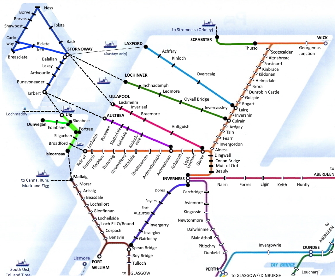
The dashed lines are proposals for light railways around 1900. The branch from Cononbridge to Cromarty was partly constructed but never completed (see - there is a precedent for Crossrail and HS2▸ ) and the branches to Ullapool and Lochiver never got off paper at all. To my knowledge, the only proposed light railway in The Highlands that got through to opening was Wick to Lybster - though Highlands in name and not in fact. Further south, the Mallaig and (?) Fort Augustus lines were being built around this time too.
So that map represents a stage in the evolution of planned routes from the long list the 1900 Walpole commission start out with (including lines to Altbea and Laxford, across Skye, and a network(!) on Lewis), to the ones with railways acts (Ullapool, Altbea), then surveyed, then started, and then the very short list indeed of those completed. There's a lot of stuff on this on Andy Drummond's website (he wrote a recent book on Garve-Ullapool), and for those who like visiting parallel universes (well, where else this year?) he has a full timetables and fares for all these railways, and a journey planner. Oh, and a "new" route diagram:  |
|
|
|
|
 Logged
|
|
|
|
|
Reginald25
|
 |
« Reply #17 on: December 13, 2020, 17:42:58 » |
|
7 A- Bromley South
B- Hayes
C- Petts Wood
D- Orpington
E- Shortlands
pre 1998 (Elmers End to Addiscombe line closed in 1997 and converted to Tramlink later)
Yes ... though I left "A" floating somewhere in fresh air and was expecting "Bromley North". Comes from the early 1960s - from the Beeching report showing lines in London to be closed or modified. Just off the map area shown, Woodside to Sanderstead was in black - earmarked for closure. London Commuter areas got off relatively lightly. Crystal Palace High Level, Greenwich Park, Gravesend West and Westerham has already been lost by that time I recall (from a study of history, not personal knowledge, you will appreciate!) Agreed - shouold have been Bromlet North. |
|
|
|
|
 Logged
|
|
|
|
|
eightonedee
|
 |
« Reply #18 on: December 13, 2020, 18:08:13 » |
|
10 Looks like a GWR▸ network map from the 1923 to 1948 era of North Wales - which I think means-
A = Llangollen
B = Bala
C = Ruabon
D = Corwen
E = Festiniog
|
|
|
|
|
 Logged
|
|
|
|
|
grahame
|
 |
« Reply #19 on: December 13, 2020, 18:26:41 » |
|
10 Looks like a GWR▸ network map from the 1923 to 1948 era of North Wales - which I think means-
A = Llangollen
B = Bala
C = Ruabon
D = Corwen
E = Festiniog
It's even older - from the 1902 GWR timetable map. Or newer because it's from a much more recent reprint  . You can "tell" the age because the GWR ends at Oswestry; important (i.e. GWR) lines are shown in thick red and unimportant (i.e. other company) lines are shown in thin black. I'll give you those stations ... letters floating a bit, and I would suggest that Bala is actually Bala Junction and Llangollen is perhaps nearer to Berwyn. Both are close pairs; indeed, I walked between both pairs in about the year 18BL (Before Lisa) - derelict at Llangollen, and shrunken at Bala Junction. |
|
|
|
|
 Logged
|
Coffee Shop Admin, Chair of Melksham Rail User Group, TravelWatch SouthWest Board Member
|
|
|
|
grahame
|
 |
« Reply #20 on: December 14, 2020, 00:16:22 » |
|
Solved so far ... 1. West London, 1870, Oxonhutch A - Addison Road (now Kensington Olympia), B - West Brompton, C - Hammersmith, D - Edgware Road, E - Bayswater. 3. Swansea Bay, 1963 - Froome A is Llangennech B is Landore Junction C is Swansea High Street D is Swansea Victoria E is Gowerton South 5. Highlands / North West Scotland, 1900, Stuving and eightonedee Garve (C) - Ullapool (A); Cononbridge (F) - Cromarty (E); Culrain (D) - Lochinver (B) 7. South East London, 1962, Reginald25 A- Bromley North B- Hayes C- Petts Wood D- Orpington E- Shortlands 8. Tyneside, 1938, Lympstone Commuter A) Walker Gate. B) Walker. C) Percy Main. D) Manors E) High Shields 9. South West Ireland, 1995, TonyN A: Barrow bridge B: Snowhill tunnel C: Waterford D: Enniscorthy E: Rosslare Europort F: Wexford 10. North Central Wales - 1902, eightonedee A = Llangollen or Berwyn B = Bala Junction C = Ruabon D = Corwen E = Festiniog Still awaiting answers (anyone now?) .. 2.  4.  6.  |
|
|
|
|
 Logged
|
Coffee Shop Admin, Chair of Melksham Rail User Group, TravelWatch SouthWest Board Member
|
|
|
|
ellendune
|
 |
« Reply #21 on: December 14, 2020, 20:38:58 » |
|
Is 6 the area around Chiswick?
|
|
|
|
|
 Logged
|
|
|
|
|
stuving
|
 |
« Reply #22 on: December 14, 2020, 22:49:53 » |
|
Is 6 the area around Chiswick?
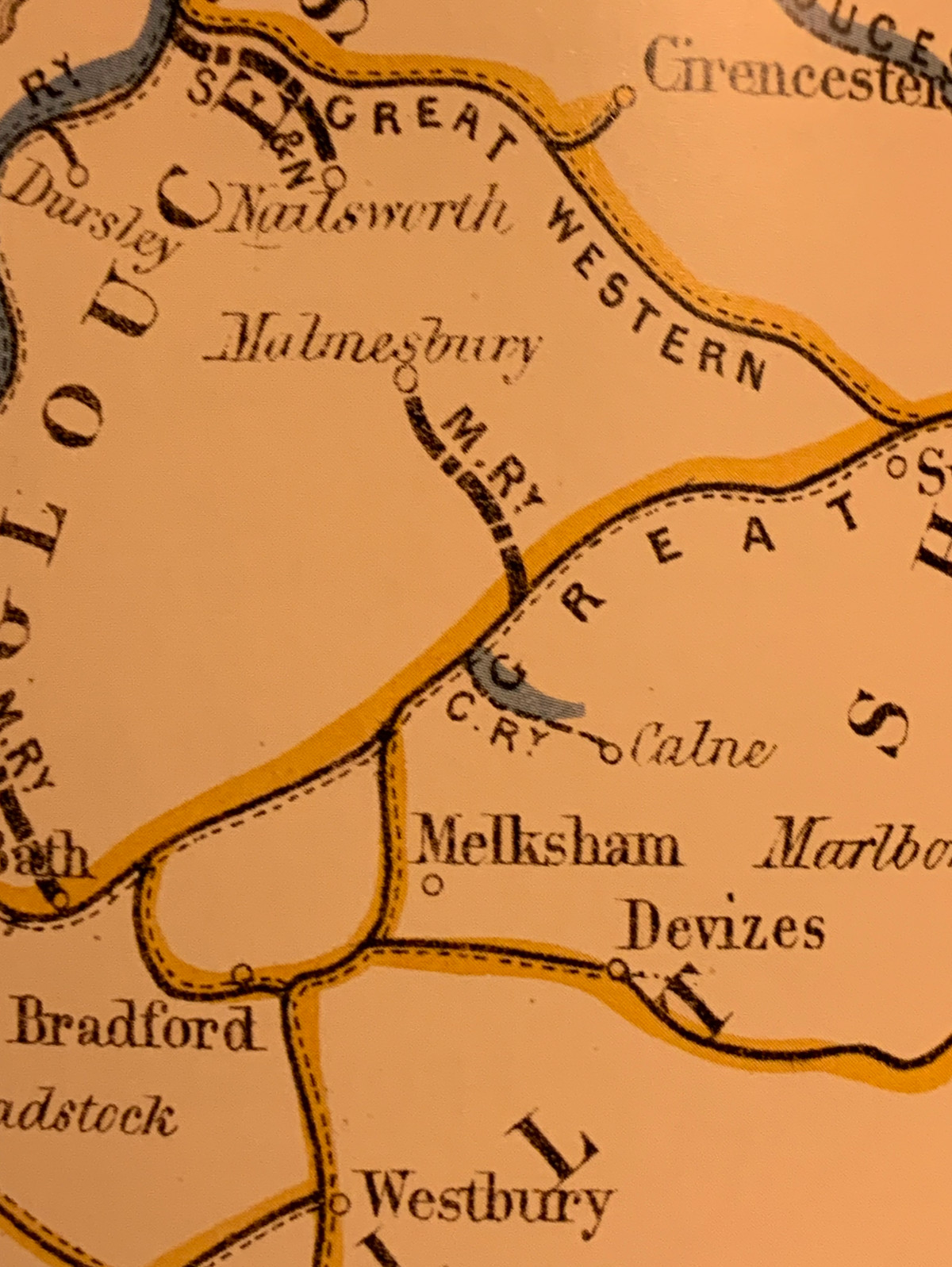
I think it's much closer to home - Graham's home that is. How about this? A is Melksham. Seems a bit far from the line, but then it was before new building crept towards the station. B is Calne. C is Bradford-on-Avon D is ... Malmesbury? see below. E must be Bath, also showing the Midland's line to Queen Square. F is Devizes. I can't get the dashed line alongside to mean anything - not broad gauge, for a start. Now, the line built via Malmesbury didn't run there, and was built by the GWR▸ . But an earlier proposal for the Wiltshire and Gloucestershire Railway did turn off at Christian Malford, which is the route shown, and the broad line would indicate non-GWR (odd though it seems). So what the map shows is dateable as about 1862-1871. |
|
|
|
|
 Logged
|
|
|
|
|
TonyN
|
 |
« Reply #23 on: December 14, 2020, 22:58:46 » |
|
The only thing that dosen't seem to fit is the Junction at Bathampton seems to point the wrong way?
|
|
|
|
|
 Logged
|
|
|
|
|
stuving
|
 |
« Reply #24 on: December 14, 2020, 23:13:27 » |
|
The only thing that dosen't seem to fit is the Junction at Bathampton seems to point the wrong way?
True, but not the only small area of questionable cartography. And there's that mysterious water feature next to the Calne branch, too. But on the whole? |
|
|
|
|
 Logged
|
|
|
|
|
grahame
|
 |
« Reply #25 on: December 14, 2020, 23:55:22 » |
|
Is 6 the area around Chiswick?
I think it's much closer to home - Graham's home that is. How about this? A is Melksham. Seems a bit far from the line, but then it was before new building crept towards the station. B is Calne. C is Bradford-on-Avon D is ... Malmesbury? see below. E must be Bath, also showing the Midland's line to Queen Square. F is Devizes. I can't get the dashed line alongside to mean anything - not broad gauge, for a start. Now, the line built via Malmesbury didn't run there, and was built by the GWR▸ . But an earlier proposal for the Wiltshire and Gloucestershire Railway did turn off at Christian Malford, which is the route shown, and the broad line would indicate non-GWR (odd though it seems). So what the map shows is dateable as about 1862-1871. Yes ... and I would agree about the rather questionable cartography. Very much old fashioned and there appears to be a degree of artists' impression in there in addition to the distortions of my removal of the text.  |
|
|
|
|
 Logged
|
Coffee Shop Admin, Chair of Melksham Rail User Group, TravelWatch SouthWest Board Member
|
|
|
|
Reginald25
|
 |
« Reply #26 on: December 15, 2020, 07:07:15 » |
|
The line from BOA which now joins the GW» mainline facing Bath, shows it facing Box only. I wasn't aware that change happened but it confused me!
+
|
|
|
|
|
 Logged
|
|
|
|
|
Oxonhutch
|
 |
« Reply #27 on: December 15, 2020, 09:31:11 » |
|
OK, let me have a stab at No. 2: Between 1975 and 1982 the Fylde/East Lancs area. A: Blackpool North, B: Blackpool South, C: Kirkham & Wesham, D: Blackburn, and E: Squire's Gate. It would be after the South Fylde line was reduced to a shuttle service and before Blackpool Pleasure Beach, Moss Side and Lostock Hall stations (re)opened. Salwick station, served by one morning and evening train only - for the BNFL works - is missing.
|
|
|
|
« Last Edit: December 15, 2020, 09:38:16 by Oxonhutch »
|
 Logged
|
|
|
|
|
grahame
|
 |
« Reply #28 on: December 15, 2020, 09:38:25 » |
|
OK, let me have a stab at No. 2: Between 1975 and 1983 the Fylde/East Lancs area. A: Blackpool North, B: Blackpool South, C: Kirkham & Wesham, D: Blackburn, and E: Squire's Gate. It would be after the South Fylde line was reduced to a shuttle service and before Blackpool Pleasure Beach and Lostock Hall stations (re)opened. Salwick station, served by one morning and evening train only - for the BNFL works - is missing.
Hmm ... it does sorta-fit, but, no, too far north, I'm afraid. Salwick would have been another excellent choice for yesterday's timetable quiz, wouldn't it? (And before you look at that, no, it isn't one of the answers!) |
|
|
|
|
 Logged
|
Coffee Shop Admin, Chair of Melksham Rail User Group, TravelWatch SouthWest Board Member
|
|
|
|
grahame
|
 |
« Reply #29 on: December 16, 2020, 17:09:17 » |
|
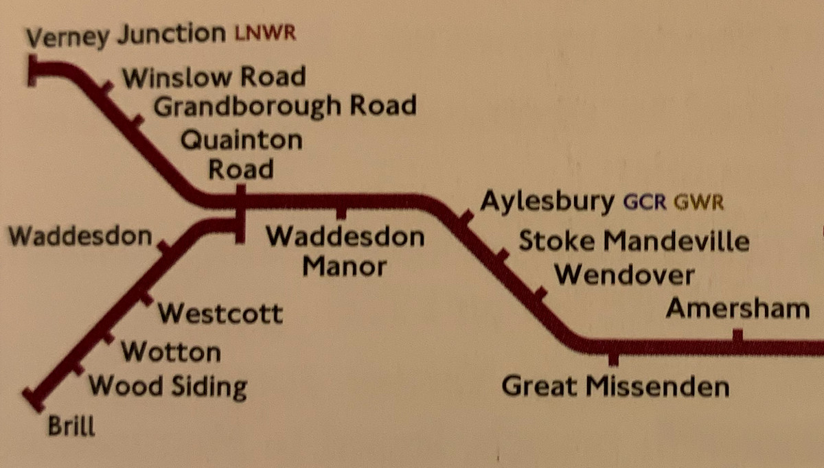
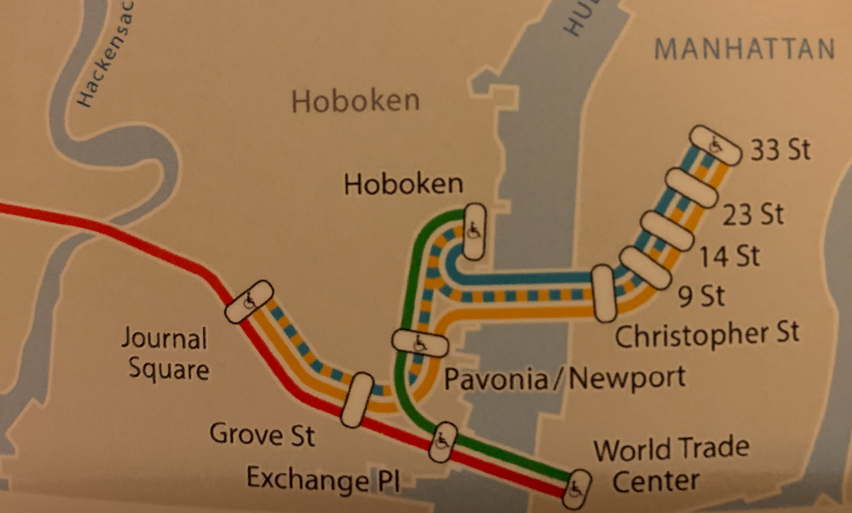
Let me complete those for you ... 2. I asked about ...  ... which I thought was a Brill quiz though it Wood send some of you up a Siding ... ... and filled in, that is  4. I asked about ...  Although very much at the Centre of World Trade, it's not close to home and I probably should have Exchanged it for a Place more familiar to our members. ... filled in that is  |
|
|
|
|
 Logged
|
Coffee Shop Admin, Chair of Melksham Rail User Group, TravelWatch SouthWest Board Member
|
|
|
|


