|
paul7575
|
 |
« Reply #45 on: February 05, 2014, 10:35:57 » |
|
Regarding Dawlish, what came first? I read a local newspaper report yesterday that said something like 'the railway was built along the town's sea wall'.
Is it not more accurate to say that following the building of the railway along the foot of the cliffs the town of Dawlish developed (or at least expanded) behind it at that point?
So it's all very well 'considering the inland route' but the coastal protection would still have to be maintained by someone, and the Act allowing it to be built probably requires that to be done by the railway 'in perpetuity'...
Paul
|
|
|
|
|
 Logged
|
|
|
|
|
Tim
|
 |
« Reply #46 on: February 05, 2014, 10:55:50 » |
|
someone needs to maintain the sea wall for sure. But I suppose that if the railway was shifted off the top of it there might be more options to use some of the space to build up the wall.
We do need an inland route. We can't simply disconnect such a large area from the rail network when the weather gets bad. Abandoning the route completely would mean some significant towns would loose their stations which would be bad.
How about a compromise of a new high speed inland route and the existing route retained for stopping services. You could perhaps single the existing route which would give a little more space between the trains and the sea and some more space for building up the defences
|
|
|
|
|
 Logged
|
|
|
|
|
BBM
|
 |
« Reply #47 on: February 05, 2014, 11:06:40 » |
|
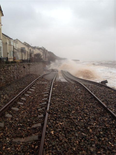
I'm attaching another photo of the damage, it's just been posted to the WNXX▸ forum.
|
|
|
|
|
 Logged
|
|
|
|
|
ChrisB
|
 |
« Reply #48 on: February 05, 2014, 11:18:12 » |
|
The answer I guess is for this to be repaired & another (external) sea wall to be constructed (which will obviously take up the beach area (if any).
|
|
|
|
|
 Logged
|
|
|
|
|
chuffed
|
 |
« Reply #49 on: February 05, 2014, 11:23:14 » |
|
Some reports suggest that there has been so much erosion that the beach at Dawlish may well have dropped some 10 or 12 feet, leaving more bedrock exposed. I suppose that could be used to anchor whatever is deemned necessary to protect the existing sea wall.
|
|
|
|
|
 Logged
|
|
|
|
|
chopper1944
|
 |
« Reply #50 on: February 05, 2014, 11:41:09 » |
|
With problems between Castle Cary and Taunton, Exeter and Newton Abbot/Totnes as well as branch lines in Devon and Cornwall, no mention of Cowley Bridge so far, and various maintenance enhancements between Taunton and Tiverton Parkway various serious consideration needs to be given to doubling the line completely between Castle Cary and Yeovil Junction, Yeovil Junction and Exeter to provide a more robust alternative to Paddington to Exeter via Castle Cary. With regard to Dawlish I believe the Environment Agency has drawn up a 10 point plan to protect the line through Dawlish but the recent ongoing events would appear to be considerably worse than what happened in the 1960's. Perhaps consideration should be given to reinstating the line between Exeter and Plymouth via Okehampton or digging out the GWR▸ plans from the archives of Devon County Council for a faster inland route between Exeter and Newton Abbot. In this day and age it is a poor reflection of how the South West peninsula is perceived in Whitehall from a railway point of view. I know there will be a cost whatever is eventually decided, but the fact that at the present time a City as large as Plymouth is effectively not connected to the rest of the rail network is a disgrace, well done Beeching and the old regional rivalries which still persist to this day which decimated the routes in the South West!!
|
|
|
|
|
 Logged
|
|
|
|
|
marky7890
|
 |
« Reply #51 on: February 05, 2014, 12:05:02 » |
|
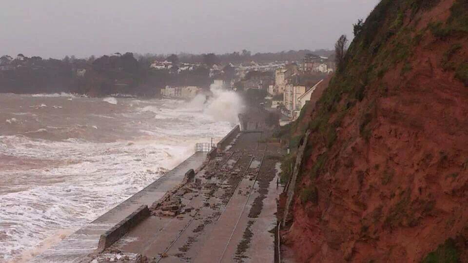
Network rail just posted this photo on twitter. The bit that has been washed away appears to be where the walkway along side drops down, and so the sea wall is much thinner. The walkway seems to have stopped the rest of the track being washed away.  |
|
|
|
|
 Logged
|
|
|
|
|
ChrisB
|
 |
« Reply #52 on: February 05, 2014, 12:15:06 » |
|
This looks a lot more than 30 feet....  |
|
|
|
|
 Logged
|
|
|
|
|
stebbo
|
 |
« Reply #53 on: February 05, 2014, 14:19:09 » |
|
Been predicted for a few years now. How easy would it be to dust off the old inland route from Exeter to Newton Abbot, though I'm not sure if that would be susceptible to high speed running? Going via Okehampton would require two train reversals for Penzance - Paddington. But both of these would make electrification easier.
How about diverting some of the HS2▸ cash to preserve an existing line to an important part of the countryside?
|
|
|
|
|
 Logged
|
|
|
|
|
PhilWakely
|
 |
« Reply #54 on: February 05, 2014, 14:27:57 » |
|
Been predicted for a few years now. How easy would it be to dust off the old inland route from Exeter to Newton Abbot, though I'm not sure if that would be susceptible to high speed running? Going via Okehampton would require two train reversals for Penzance - Paddington. But both of these would make electrification easier.
How about diverting some of the HS2▸ cash to preserve an existing line to an important part of the countryside?
Far easier to reinstate the Okehampton to Bere Alston link and make it usable at reasonably high speeds. The old Teign Valley route has been virtually obliterated and was only single track suitable for 14xx with Auto coaches. |
|
|
|
|
 Logged
|
|
|
|
|
thetrout
|
 |
« Reply #55 on: February 05, 2014, 14:32:45 » |
|
I decided to return on 1C87 the 1448 ex PAD» , and not bother waiting for the 1703 (and missed meeting thetrout - sorry).
No worries  I have a habit of appearing on a train in the very near future  BTW▸ , 1C87 not booked to stop at Westbury, but ran through the station rather than the avoiding line - points failure again?? (see my earlier topic about Totnes - is it me?!)
The 17:03 also ran via Westbury Station, Platform 1 but did not call there. There is a large lake near the avoid line so could have been flooding (Mere speculation) What is more likely IMO▸ is setting the points in the same position for the Up/Down trains that do call at Westbury. With the poor weather it may have been overcautious working to prevent the points failing. I believe this is done when there is snow around... Even if it is the wrong type of snow...    |
|
|
|
|
 Logged
|
|
|
|
|
paul7575
|
 |
« Reply #56 on: February 05, 2014, 14:39:17 » |
|
Large lake <> 'mere' speculation! Nice connection there...  Paul |
|
|
|
|
 Logged
|
|
|
|
|
ChrisB
|
 |
« Reply #57 on: February 05, 2014, 14:42:02 » |
|
Have we seen this one?  |
|
|
|
|
 Logged
|
|
|
|
|
chopper1944
|
 |
« Reply #58 on: February 05, 2014, 14:43:35 » |
|
Pages 142 and 156 of the GWR▸ in the 20th Century by O S Nock (Paperback) make interesting reading about the proposed Exeter to Newton Abbot route. One has only to look at a map of the network post the proposed electrification to see the great blank space that is the SouthWest peninsula. A new vision for the rail network in the far South West needs to be looked at as the present one of make do and mend is obviously not going to be fit for purpose in future especially with all the climate change that is being likely to happen. Some of the HS2▸ money would be better spent reinforcing the rail network in the south west but this is unlikely to happen unless the government stops being so London centred.
The latest estimate for the line to be working again is 4-6 weeks, weather permitting!! Some thinking outside the box is required other than just repairing until the next time.
|
|
|
|
|
 Logged
|
|
|
|
|
ChrisB
|
 |
« Reply #59 on: February 05, 2014, 14:46:18 » |
|
|
|
|
|
|
 Logged
|
|
|
|
|


